
Peta Dunia Zaman Dahulu
Spoiler for World Map 2nd Century

Description: Ptolemy world map ca. 150 AD.
Claudius Ptolemaeus, known in English as Ptolemy, was a mathematician, geographer, astronomer and astrologer who livied in the Hellenistic culture of Roman Egypt. One of his main works is his Geographia, a compilation of what was known about the world's geography in the Roman Empire at his time.
The map is a reconstruction made in the 15th century..
Spoiler for World Map 7th Century

Description: T-O map from the 7th century, the early Middle Ages, with the description of the world according the Etymologiae of Isidore of Sevilla, who was Archbishop of Seville/Spain for more than three decades. This T and O map is a copy from the 12th century.
Spoiler for World Map 11th Century

Description: "Cotton" of Anglo-Saxon world map (c. 1040) appears in a copy of a classical work on geography (British Library; Cotton MSS, Tib. B. V, folio 56.)
Spoiler for World Map 12th Century
_1190+-+Kopie+%282%29.PNG)
Description: World map made in 1190 by the German or Burgundian theologian Honorius Augustodunenesis, also known as Honorius of Autun.
Spoiler for World Map 12th Century

Description: Al Idrisi's world map.
Made by Arab cartographer and geographer Abu Abd Allah Muhammad al-Idrisi in 1154 under the court of King Roger II of Sicily.
Note that south is at the top of the map.
Made by Arab cartographer and geographer Abu Abd Allah Muhammad al-Idrisi in 1154 under the court of King Roger II of Sicily.
Note that south is at the top of the map.
Spoiler for World Map 13th Century

Description: "Psalter World Map" is a detailed T-O Map drawn by an unknown author around 1260.
Spoiler for World Map 14th Century

Description: World map made around 1420 by the Italian cartographer Pietro Vesconte.
Spoiler for World Map 14th Century
Europe

Middle East

East Asia

Description: The Catalan Atlas produced in 1375 by the Majorcan cartographers Abraham and Jehuda Cresques is the most important Catalan world map of the Middle Ages. The world map originally consisted of various leaves.
Spoiler for World Map 15th Century

Description: The "Columbus map" which perhaps was drawn by Christopher Columbus and his brother Bartolomeo in Lisbon around 1490 before the discovery of the New World, showing the known world in their time.
Spoiler for World Map 15th Century

Description: World map of Hartmann Schedel published in the Schedel's World Chronicle in 1493 showing Europe, Asia and Africa. Schedel (1440-1540) was a German physician, humanist and historian, one of the first cartographers who used the printing press.
Spoiler for World Map 15th Century

Description: Historical world map from Johannes de Armsshein, published in 1482 in Ulm/Germany at the base of Ptolemy's view of the world.
Spoiler for World Map 16th Century

Description: Orbis Terrarum published by the Dutch astronomer, cartographer and clergyman Petrus Plancius in 1594.
Spoiler for World Map 16th Century

Description: Map of the world 1552 by the Siebenbuerger Saxon humanist and Protestant Reformer Johannes Honterus.
Spoiler for World Map 16th Century

Description: World map of the Dutch explorer, cartographer, astronomer and painter Johannes Ruysch published in 1507. Ruysch's work is the second oldest known printed map showing the New World
Spoiler for World Map 17th Century

Description: World map made by the Dutch cartographer Joan Blaeu in 1664.
Spoiler for World Map 17th Century

Description: Novissima Totius Terrarum Orbis Tabula made by the Dutch timber merchant Joannes de Ram, first published in 1683.
Spoiler for World Map 17th Century

Description: World map from 1666 by Peter Goos, a Dutch cartographer, engraver and bookseller.
Spoiler for World Map 18th Century

Description: Engraved world map by the German cartographer Leonhard Euler first published 1753 in his school atlas "Geographischer Atlas".
Spoiler for World Map 18th Century

Description: World map with the trade winds from the German or Dutch cartographer Herman(n) Moll first published in England 1719. Picture from Atlas Minor, 3rd edition, London 1736.
Spoiler for World Map 18th Century

Description: World map
Published by: Vrista
Published by: Vrista
Spoiler for World Map 19th Century

Description: Dutch world map from Otto Petri published in 1860.
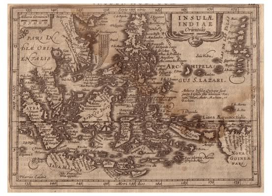
Spoiler for Indonesia Map 1631
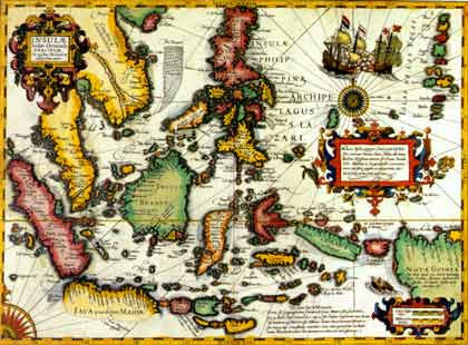
Spoiler for Indonesia Map
Tidak ada komentar:
Posting Komentar